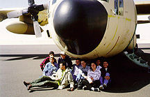
Above all: Egyptian Air force plane: C-130!
Check this photo
|
From left to right: Borhan
(red shirt), Eiman (with veil), Karim
(long legs!), Fadi (with a cap), Medhat
(beside Fadi), Moataz (fourth from
right), Amany (with striped shirt),
Hossam (behind Amany), Ghada
(first from right)
Above all: Egyptian Air force plane: C-130! Check this photo |
At 7:30 a.m., we took the Armed Forces buses to the east of Cairo's military air base. We were shocked to see the airplane that would take us. The plane was a C-130, which is a military cargo airplane, used to carry tanks and vehicles normally! In our case, some seats were installed for us to use.
The participants of the trip were from Cairo, Al-Azhar, and Ain-Shams universities, agriculture departments. In addition, media personnel from the Egyptian TV, and Nile TV, and journalists from most Egyptian newspapers (were also there). We were also filmed by most of them, especially the Nile TV people, who were glad to find English-speaking students on the trip!
As an introduction, East of Owainat is located in the extreme south of Egypt, only about 20 km away from Sudan.
In this place, there is a large water aquifer. This water aquifer could be used for irrigation and reclamation of around 10,000 feddans for more than 100 years. So, it was the decision of Egypt to start in this land. In addition, this place is very close to the Toshka project zone. So after the water aquifer is used up, it can depend on the water coming from the Sheikh Zayed Canal and the Toshka project.
The decision of using this large water aquifer is not a recent one. In the late '70s, the distinguished Egyptian scientist Dr. Farouk El-Baz, who was the scientific advisor to late President Anwar Sadat, started his research about the availability of water in this zone. El-Baz, who was a consultant to NASA's Apollo program, in addition to being the initiator of the new field of remote sensing, was able to determine the amounts of water available in this zone. By using very advanced remote sensing techniques (satellite images and radar), he was able to reach a conclusion that "the Egyptian Western Desert is floating on a massive water reservoir!"
But due to the hard conditions we were facing in Egypt throughout the '80s, the project remained frozen on paper. Recently, they (decided) that it is almost the right time for the project. So, the green light for the project was give around 1996/97.
However, it was very difficult for the country's private or public sectors to work there; the region had no airports at that time, and conducting studies was very expensive. So, the decision was taken that the armed forces would be the (party) responsible for this great project.
We arrived at around 11:00 a.m. in Owainat airport. Major General Dr. Mashaal, the head of the NSPO (National Service Projects Organization), introduced us to the project. He started his presentation by talking about the significance of the national projects. He said that the Suez Canal and the Aswan High Dam were examples of these projects. We have to expect criticism and other counter-arguments against these projects because they are long-time projects. Some people are far-sighted enough to see the outcome of such projects. He explained why the Armed forces work on this project. He explained that the armed forces have great human and technical resources. Now, we are in time of peace. So these forces have to be directed to serve the country, and to help the army itself to self-cover its expenses.
Major General Mashaal explained the importance of such a project. He said that the Egyptian population doubled more than 25 times in two centuries. However, the agricultural land we used since that time is almost unchanged. So, we have to go out of the Nile Valley. He highlighted the importance of this by explaining the bad distribution of the Egyptian population.
He also said, "We have here an aquifer that can last for around 100 years. So shall we leave it unused so that after 100 years we may find a military conflict starting on it? We know very well the coming war in the Middle East, and everywhere there is a war over water resources."
Next, Major General Engineer Shihabi started his presentation about the project. He explained how the satellite images show the importance of such a zone. He showed the tough and harsh conditions they lived in. However, only the armed forces can make it. He showed that the land being reclaimed is around 1000 feddans, and the 9000 feddans will be given to other investors.
After the Friday prayer, we started our trip to the fields. It was very nice to see wheat and other crops starting to (bloom). We took many photos around the fields and the underground wells.
At around 5:00 p.m., we started making our way back to Cairo. When we landed in the military base, it was heavily raining in Cairo.
On our way, Brigadier General Afifi talked with us about why the armed forces do this. He said, "I hope you will not go and say that we have seen the armed forces working as farmers. We are ready on the military side. However, we are now in the time of peace. So, shall I leave the vehicles in their places unused? No. You know, the same truck we use to carry the soldiers is the one we use in Owainat. It is the same tractor that we use to plant that we use to build sand shields and put barriers during war time."
Really, it was an outstanding trip. Thanks to the armed forces for first inviting us, we the Egyptian students, to see such a place. Secondly, for making all this (effort) for us. They are really as Prophet Muhammad (PBUH) said about them, the best soldiers on earth!
Moataz M. Attallah